(This is the Day 2 entry for the 30 day world building challenge.)
The geography of Oed is as varied as the pastries cooked by the fifth Lord’s master pâtissier. The following is an excerpt from the JE Atlas, a series of geographical and anthropological surveys performed by the team of expert spelunkers Jula and Ela, during the rule of the Crow.
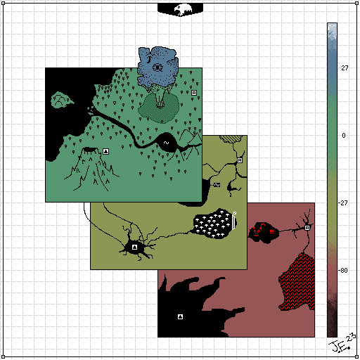
We travelled by kamel north for many months, to an uncharted quarter of The Crow’s Plaines. This land seemed similar to the arid plains of Mehco. On the surface a vast grassland sprawled as far as we could see, and the landscape was populated by old desert trees, snitch-arms, and reezels. We first encountered a large empty mountain, several travels tall, and just as wide. We prepared the gear and the Gears, and attempted to descend. About 20 travels down and the emptyness started to branch off into small tunnels and caverns, so at 27 travels we camped for the night. In the morning we had traced at least 12 of these, all leading to dead ends, before stumbling across a vast cavern with glorious angled ceiling. The cavern was glowing, filled with glowing mushrooms and other life. To our shock we found evidence of civilisation — a large sand-steel wall — but could not find a way through. A curious symbol was etched on the wall, it looked like [Entry Removed]. Further descent of the empty mountain resulted in no other great finds, nonetheless we graphed the terrain down to 80 travels. – Jula
After mapping the mountain we continued across the plain, and encountered a calm cerulean river bisecting the region, opening to a delta in the sea, and forming a lake near the hills. A wet-descent of the lake revealed it to be surprisingly empty, but deep, very deep. We could only graph 2 travels down before the water became too murky and the pressure too great to continue. The next geographical marvel we encountered was a giant stone column, rising up into the heavens and supporting a massive land mass. By the rate of travel of its shadow across the ground we estimate it to be no less than 15 travels above ground and at least 8 travels in diameter. The sheerness of the column made it impossible to climb, but nonetheless we have graphed the visible outline and Jula has imaginatively filled in the interior based on a dream he had while we slept in its shadow. (Which, by the way, was curiously devoid of any flora whatsoever.) – Ela
As our resources were dwindling we decided to expedite the drill phase of our survey. Site A (in the top-right sector of the graphed region) took an entire day to initialise as the drilling machinery needed much maintenance. It was nightfall before we descended. As the drill churned the rock below us, we rappelled down, analysing the various substrata and compiling the results into Document A3 (attached). Of particular interest was the abundance of heatstone, which made the journey much more uncomfortable than usual. At a depth of 27 travels, hoping to find the other side of the sandsteel wall, we spent the next 12 hours exploring the myriad cave networks, some of which were only just wide enough to squeeze through. A small incident occurred as we needled samples from the rock — warm water started gushing through the hole, which required immediate plugging. Based on our coordinates, the water source was either the lake we found above ground (making it the deepest lake we are aware of), or an underground river, but considering the pressure of the expellation we assume the former. [Ed: The lake in the figure is now known as The Great Crow’s Deep Lake] Tomorrow we descend further than we have ever been, I’m excited! – Jula
We slept the night at -27 travels — not our first underground slumber by far. We programmed the drill to descend to -100 travels then to return to the surface. In the morning we found it had broken down at -80 travels, w
here the stone had become extremely hard, black, and quite warm to the touch. It wasn’t heatstone, but something different. We couldn’t take samples as our equipment was not fine enough, we have marked the exact coordinates for The Crow’s Jeweller. We could not repair the drill, but considering it had lasted over 17 large-months, it was well past retirement and so we left it there. Another day of spelunking the caves revealed a vast connected network of caverns and tunnels. To the south of Site A we found a great chasm fill with molten heatstone, we could only get within 10 jumps before the heat overwhelmed us. And this is where our technical survey ends and the descent into fiction begins. Jula, spelunking westward on our last day at -80 travels, came back later in the day, shivering and with minor burns all over him. I treated him as best as I could, but the physical ailments were not the issue, I could no longer communicate with him, as he was speaking nonsense. After several days manual ascension we got to the surface and I helped Jula onto his kamel. Before our journey to the nearest Tower I got the map from Jula to make some final remarks. To my surprise he had graphed the region he was exploring just before the incident, it seems he had found a medium sized cavern just west of Site A. However, when I looked closer, demonic eyes were etched into the paper, underneath them a hideous smile, and above, long curved horns. I looked up at Jula, he was staring at me, and I swear I saw a flicker of flame in his eyes. – Ela
